Garmin expands radar altimeter product line with complete low-cost solution.
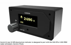
Garmin International Inc., a unit of Garmin Ltd., the global leader in satellite navigation, has announced a comprehensive radar altimeter solution that expands upon Garmin’s high-performance, all digital GRA 5500 radar altimeter to include the GRA 55, a best-in-class and cost-effective radar altimeter designed specifically for helicopters and general aviation aircraft. The GRA 55 leverages Garmin’s patent pending digital signal processing technology that works to provide smooth altitude tracking and results in a consistent and highly accurate above ground level indication, even in the most challenging environments such as rough terrain, tree canopies, sand and choppy water. The new GI 205 stand-alone indicator, designed to pair with the GRA 55 or GRA 5500, provides a comprehensive, stand-alone radar altimeter solution for operators seeking a cost-effective display.
“Garmin is excited to extend our industry-leading radar altimeter products to a broader range of markets, while meeting the latest design standards and ultimately providing pilots with rock-solid confidence of their altitude above ground,” said Carl Wolf, Garmin’s vice president of aviation sales and marketing. “In addition to meeting the most rigorous altitude accuracy requirements only previously seen in products for transport and military aircraft, the GRA 55 and GI 205 help fulfill recent FAA requirements for radar altimeter equipage in commercial helicopter operations.”
Patent-pending technology in the GRA 55 incorporates built-in self-test monitors that continuously cross check system and data integrity, assuring the pilot of an accurate measurement of the height above ground. This technology also provides for a simpler installation with easy calibration and eliminates the requirement for long lengths of antenna cables that are traditionally required in the installation of radar altimeters.
Source: www.verticalmag.com; March 2014.